
…or How my GPS tried to kill me and feed me to dogs as I took photographs for Rye and Ginger
Gentle Reader,
Researching and writing about food and history isn’t all sunshine and cupcakes. Sure, there are paper cuts and scalds, but it can also be a harrowing, heart-in-the-throat experience! What follows is an example of the lengths I go through to provide you, my dear and lovely followers, with a respite from your day. This is long, so grab a cup of tea and a cookie or two.
Often the issue when writing about matters of history and foodways isn’t locating sources, recipes or even the words. The challenge frequently lies in finding authentic historical images to accompany the text.
Yes, yes, various museums and libraries and repositories have done marvellous jobs uploading their holdings for all and sundry to see and use. But sometimes—just sometimes—I can’t find what I want. The images are bad or mislabelled or aren’t available for (free) use.
As the bright minds at the University of Waterloo seem to be preoccupied with the nesting habits of campus geese and haven’t yet invented time travel, I continue to rely on creativity and mindreading as much as dumb luck when searching for illustrative images to be used with Rye and Ginger articles.
Case in point: Queen’s Bush: We marched right into the wilderness. Images from mid-19th Century Upper Canada exist, but for one reason or another, I can't use them. They are tangential, unofficially borrowed or don’t depict the Queen’s Bush Settlement.
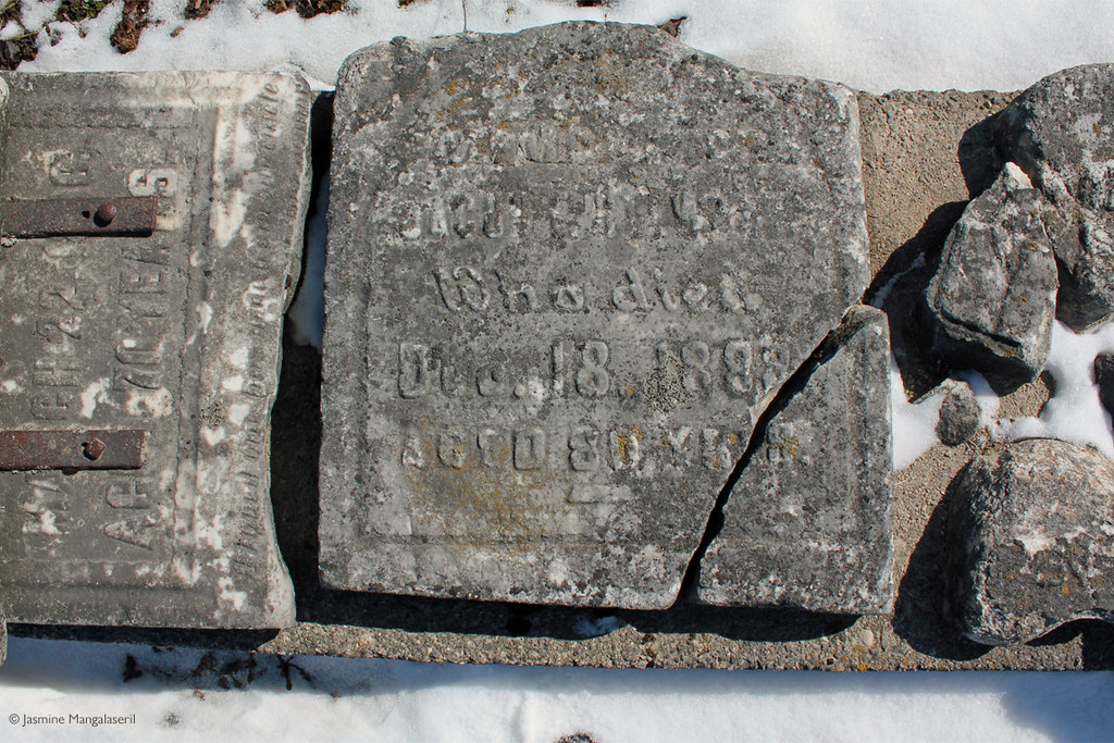
“No worry,” thought I. “There’s a small collection of Queen’s Bush headstones somewhere out in the country. I’ll just find and photograph them.”
Note the phrase, “somewhere out in the country.”
Note the other phrase, “I’ll just find them.”
I believe my ability to get from points A to B is “mythical,” “whimsical” or “fanciful,” even. My friends, however, are more likely to describe my sense of direction as “non-existent.”
(For the record, I think this directional discord can be credited to my upbringing in Kitchener-Waterloo, Ontario. One of our many local charms, amongst the butter tarts and pronunciation of “Weber” (WEEE-bur, sometimes VEEE-bur, but not Webb-ur), is having three major streets that each run in all four directions. Another example of our idiosyncratic street sense is over the course of some 14 kilometres, one of our roads has eight names. Probably best not to bring up the fact that while parallel, Weber and King (pronounced “King”) intersect three times (perhaps four—it’s debated).
Locating the headstones on Google Maps was trivial. There they were, on the side of a country road, right here in Waterloo Region. The straightforward route presented no seemingly bizarre twists or turns. My car wasn't required to transform into a boat or helicopter to get there and back. Best of all, the estimated drive times were relatively short and ranged from 30 to 40 minutes.
I printed off the directions, gathered the camera, bundled up in my woolly Cookie Monster blue coat and Kermit The Frog green scarf, and set off for parts barely known.
I got into my car and then asked myself: Do I use the GPS?
I am not a Luddite. I willingly surround myself and use various contraptions and gewgaws run by microchips, microprocessors, and other microwhozzits that claim to provide me with the macroconvenience, macroprecision, and macrotimesaving that every busy woman with two cats thinks she needs.
Simply put, the issue with GPSs and sat navs and driving apps is: I don’t trust them.
You see, I have a deep-seated fear of a semi-robotic voice instructing me to drive off a cliff. Or into a lake. Or into a subway tunnel. And yes, I know it’s up to me to use common sense and decide whether or not to follow directions. But the point is: if some engineer didn’t have the foresight to take away the potentials of driving off a cliff, down a pier or into a subway tunnel, and I’m driving in parts unknown in reduced visibility (like fog, teeming rain or the pitch of night), how can I trust the device won’t kill me?
Please note: I was on the team that acquired companies and technologies for a world-leading smartphone manufacturer. I worked with the guy who put together the deal that led to the phone’s travel mapping app. When he found out about my innate distrust of this particular technology, he tried to convince me my fears were unfounded. I should trust it. I should try it out.
Fine.
Although sceptical, I allowed the app to direct me to an appointment in Guelph and back. Sure, it got me there. But getting back home? It missed a crucial left turn and really wanted me to drive straight through. Where there was no road. Through a farmer’s field. In a direction that would have taken me to Ponsonby, Ennottville or possibly Inverhaugh. Not home.
My colleague was downhearted when I recounted my adventure.
Misgivings aside, I have a new GPS. Yes, I own the contraption I trust the least.
I was given one a few years ago, which I used for out-of-town trips. It generally got me to where I needed to be, and it generally got me back, but it died about eight months ago. On the back roads. Somewhere between Owen Sound and home. I had to drive home by instinct.
Let me repeat that.
I had to drive home by instinct.
Obviously, I succeeded and am not wandering the back roads of rural Ontario, like some combustion engine’d version of the Flying Dutchman. That experience did not warm me to this particular sort of doohickey.
That unit was called “Bertha”—someone once told me that if I named an inanimate object, I was more likely to think kindly of it. It doesn’t really work that way, but it gives me a name to curse.
I hemmed and hawed before I replaced her. But I do travel to the great back and beyond. And while I don’t trust the things, they do seem to know where the closest gas station is.
My new unit’s name is Eunice. I’ve been testing her out on known routes and almost unknown routes, with no major incidents worth discussing. As she’s done well so far, I decided to try her out with Waterloo’s backcountry roads.
"Really, what could possibly go wrong?" thought I.
I suppose I should have twigged there may be the teensiest of problems when I punched in the stones’ address. Eunice flashed a warning that getting to the destination involved unpaved roads.
Well, yes.
As the gravestones were on Sideroad 19, I fully expected to drive on gravel or dirt, but more to the point, since when was an unpaved road an issue? Would she also warn me about the possibility of cows in pastures or weak cell coverage or roads with a higher propensity for horse plops? Oh, Princess Eunice, you are a city girl, aren’t you?
The first leg of the journey went well. Eunice gave me accurate and timely warnings about roundabouts and turns. It looked as if it was going to be an easy and beautiful country outing.
Then, I missed a turn.
In honesty, I mistook a sideroad for a farmer’s laneway. For those who’ve only ever driven on well-lit tarmac complete with bright white or yellow lines, some country sideroads can appear similar to long, narrow farmer’s driveways. Especially when instructions are given at a long, narrow farmer’s driveway.
“No worry,” thought I. “Eunice will recalculate and give me an alternate route or tell me to turn around.”
In hindsight, I may have given her a little too much credit.
I kept driving. And driving. And driving.
At about the point I thought about turning around to find that missed sideroad, Eunice piped up with new instructions, “At the end of the road, turn right.”
Now, I’m not sure Eunice is the right name for my GPS. I named her that before I got to know her. And really, you don’t know a person until they are in a crisis.
Between the unpaved road warning and her haughty mispronunciation of Listowel as “Lis-towel” (instead of (LISS-toe-wil)) in that rather condescending Americanese voice, I think she’s really a Martha.
(Note to self: Switch her voice to British Tim—he doesn’t announce street names but my mind can easily change his pitch, timbre and tone, so I can pretend I’m driving with Benedict Cumberbatch or Tom Hiddleston or Colin Firth. “You have reached your destination.”—Really, can’t we drive around for a bit longer?)
“Now that Martha-guised-as-Eunice decided to re-join the trip, getting to the headstones would be as easy as schnitz pie,” thought I.
Several minutes later, Martha-guised-as-Eunice announced, “In 500 metres, turn right.”
Which would have been fine, if there were an appropriate right turn in 500 metres. But there wasn't. So I kept driving straight ahead, thinking she would provide less quizzical instructions.
No such luck.
“Turn left at Ruggles Road.” Ruggles Road! A name I recognised from the Google Map! It was nowhere near where I was. I didn’t turn.
Her next instruction would have led me up a farmer’s driveway. I didn’t turn.
A minute later, she declared, “You have reached your destination” in that smug tone that indicated she believed herself competent, efficient, and better than I at getting from Point A to Point B.
What? Really?
I was still on that same road and hadn’t made any of her instructed turns.
There were no headstones in sight.
I kept driving.
I was concerned, but not overly so. The air was crisp, the sky was blue with little puffy white clouds, and the car’s gas tank was three-quarters full. By my calculations, that meant I could travel 300 kilometres before I would have to develop my hitherto undiscovered survivalist skills.
Martha-disguised-as-Eunice repeated the same set of bizarre instructions, this time a bit faster and haughtier. Again, I made no turns. Again, I had reached my destination. Again, there were no headstones in sight.
She repeated the same set of instructions (again), but this time, not only a bit faster and haughtier but also a bit louder. Oh Martha-disguised-as-Eunice, I don’t need your attitude. Again, I made no turns. Again, I had reached my destination. Again, there were no headstones in sight.
Martha. Definitely a Martha.
I saw a sign down a crossroad that read, “Welcome to Waterloo Region.”
Did I leave Waterloo Region?
I pulled over as Martha babbled on as if I were still driving. I madly tapped and poked away at the screen and the power button.
It was at that moment I came to a realisation.
I wasn’t too far from where had Bertha had palpitations and died. And now, Martha seemed to enter into a mania and was **this close** to speaking in tongues. I stumbled upon Canada’s Bermuda Triangle of GPSs. The place where mapping apps led and abandoned their owners to the stoats and the groundhogs and the chipmunks in the wilds of rural Waterloo. Or rural Wellington. Or rural wherever I was.
I restarted the GPS and typed in the gravestones’ address.
Nothing.
Oh well. I’ll just drive down this road until I feel like turning down another road. It worked when Bertha had her fits.
After driving for a few minutes, Martha revived and told me to turn right. It seemed to be a good idea, so I did. More instructions followed.
Ninety minutes after I left home, I found myself on Sideroad 19.
In her earlier nattering loop, Martha trained me so well to disregard her “you have reached your destination” pronouncements when I actually reached my destination I missed it. I glimpsed the gravestones and the blue historical marker sign as I passed.
“All I have to is turn around and drive back to the spot,” thought I. “Easy peasy lemon squeezy.”
Now, Sideroad 19 was the dreaded unpaved road Martha forewarned me about. And yes, it was a road, and it was unpaved. What she thoughtfully omitted was the road was not only narrow but was held up by two sheer cliffs. In some places, I swear, the walls soared higher than I am tall. Over the edge, I peered deep into the heart of Waterloo County darkness: deep crevasses of craggy, frozen mud.
Three-point turn? I don’t think so.
I drove until I found a farmer’s driveway in which I could turn around. Little did I know, I picked the wrong laneway.
Out from nowhere appeared two dogs. Two big woofy dogs. With teeth and ears and tails and fur and barky-bark-barkiness.
Now, I’m not really a dog person, but even I could tell they were unhappy that I was anywhere near—let alone on—their land. Call it their energy. Call it the looks in their eyes. Call it their loud and incessant barking.
These sounds were nothing like the friendly little ruffs of “Hey! That’s my other human!” my neighbour’s dog, Dakota, lets out when she sees me. These barky-barks were definitely not like the “My other human is outside and I’m inside” arooos she lets out when she hears me pull into my driveway.
These were like her ominous and ongoing warnings of impending stranger danger. They were the “It’s that blasted real estate agent AGAIN, and he’s coming to steal our house and our yard!” barks.
These dogs warned anyone who would listen of the potential torturous calamity that only a woman in a woolly Cookie Monster blue coat and Kermit the Frog green scarf trespassing on their territory could bring.
The one with brown patches (whom I shall call Cerberus) barked his way to the front of the car. His yellow compatriot (whom I shall call Hank) took up woofing at the rear of the car.
If I were truly the nefarious sort, I would be in very big trouble. But I am not the nefarious sort. I just want to turn my car around and take photographs of headstones at a historic site.
When I tried to inch forward, Cerberus and Hank got louder, and they stood their grounds even firmer. I scanned the property for their owner, but none appeared.
The dogs were in charge.
After a minute of this, I saw my chance and got away. Yes, I avoided hitting either dog and no, I did not drive into the bottomless pit that served as both a roadside trench and a moat around the Cerberus and Hank Empire. They kept up their warnings but didn’t leave their land. I left their driveway. I was safe.
I travelled back about a kilometre or so and pulled over by the gravestones. I got out and picked my way over a frozen patch of broken ground and took a few photos. Behind me, two Mennonite children rode by in a horse and buggy on that gravel road Martha warned me about. We smiled and waved at one another. I had taken a few more snaps before I decided the wind was too brisk for me to stay out. Time to go home.
Inside my car, I reviewed my shots and packed my camera. I put my key in the ignition and checked my rear-view mirror.
There he was.
Emperor Cerberus, in full gallop down Sideroad 19.
It was a beautiful sight. There he was, a lovely dog taking fast, long, and determined strides. Soon, co-Emperor Hank was in sight, too. Their slightly floppy ears bobbed up and down as their paws hit the ground. The sunlight glinted off their teeth as their loud, sharp barks broke the serenity of a clear winter’s afternoon in the country.
But no, they weren’t stretching their legs or out for a little trot about the ‘hood. Those barks weren’t of the “Hey! That’s my other human!” sort. Nope. They were on a mission and in their minds, I was still the potential cause of torturous calamity, even though I was hundreds of metres away from their empire. And they were making a beeline directly towards my car.
I turned my key, put my car into gear and depressed the accelerator.
I last glimpsed Cerberus and Hank in my rear-view mirror, chasing me as I drove back onto paved roads. They disappeared as I took cover in a gaggle of Mennonite horses and buggies.
My ruse seemed to have worked. Cerberus and Hank haven’t found me. Yet.
I’m sure Dakota would let me know.
cheers!
jasmine
I'm a quill for hire!